Where is Zero on the Earth?

This is another in the series of podcasts from our trip in Europe.

Knowing exactly where you are on the earth’s surface is pretty important for most of us, and absolutely vital for airline pilots, surveyors, engineers and cartographers. Early study of location was difficult and inaccurate, hampered by lack of technology we now take for granted, and also by faulty understandings of the earth’s shape and location and movement in space.

I have long wanted to visit Greenwich, in London, to see the place which was designated as one of the ‘starting place’ for measurements on the earth’s surface, and also the reference point for time zones.

Google Map

This map shows the location of the video, and the Prime Meridian:

View Royal Observatory, Greenwich, London, UK in a larger map

Royal Observatory, Greenwich

In 1884, Greenwich was chosen as the place for the ‘Prime Meridian’, the official dividing line between the eastern and western hemispheres, the line of 0° longitude. Of course, the Equator is the equivalent line of 0° latitude, dividing the northern and southern hemispheres.

The Royal Observatory at Greenwich website includes this interesting snippet about the history of the Prime Meridian:

The Greenwich Meridian was chosen as the Prime Meridian of the World in 1884. Forty-one delegates from 25 nations met in Washington DC for the International Meridian Conference. By the end of the conference, Greenwich had won the prize of Longitude 0º by a vote of 22 to 1 against (San Domingo), with 2 abstentions (France and Brazil).

The day we visited we had to drive to Scotland and didn’t have time to go into the observatory. If you have time when you visit London, I recommend a visit to this iconic location on our planet.

Teach Roman Math

Teach your students about Roman civilization with a math connection!

I visited Chester in North England, where my brother lives with his family (he appears briefly in the video with his wife, and my wife and I). Chester is a fascinating town, which stands on top of Roman ruins, many of which no doubt have not yet been found. Basically, whenever a new building project gets underway, archaeologists have to be called in if (or more likely when) ruins are found on the site.

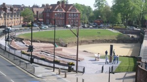
The video includes two on location shoots in Chester, the first at the town’s impressive Roman Amphitheatre, the biggest in Britain; and the second on the City Wall, built by the Romans, which is still largely complete and is a lovely walk around the city.

Math and the Romans

The Roman civilization was incredibly advanced for its time, in just about any field you can name (except perhaps moral behavior): architecture, engineering, military technology and leadership, government, art and fashion, economics, and so on. In many of these fields, mathematics would have been an essential part, just as they are today.

I suggest two straightforward “Roman Math” topics you can use in the primary or middle school classroom:

  • Numeration – study Roman numerals, compare and convert with our base ten system
  • Geometry – study tessellations and mosaics

With older classes and classes in Europe, other topics will be possible in the curriculum, and so if you are alert to the possibilities, you can link them to mathematics also.

Google Map

The map below shows the locations of the video shoot:

View Chester, England, UK in a larger map

How do you include math in your teaching of history, and ancient civilizations in particular? What other connections do you make with your students with the Romans, Egyptians, Mayans, and so on?

Teaching Slope in the Mountains of Switzerland

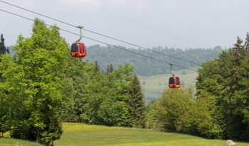
Switzerland is known for its beautiful mountains and chocolate-box scenery, summer or winter. My wife and I were blessed to visit there this last spring, so I took the opportunity to video another podcast episode. We took a cable car up a smallish mountain near Lucerne; actually probably just a hill by Swiss standards, then walked down. We’d done this before on a higher mountains when we were younger and fitter, and ended up unable to walk the next day. So this time we were a bit wary of taking on too much.

So, what about the math in this setting? The cable car and the incredible mountains, and the road tunnels that go through them all got me thinking. The swiss have developed an impressive network of roads that enable a driver to travel all over the country, in spite of the mountains that threaten to prevent travel due to their sheer size and their steep slopes.

To cater for this steep topology, Swiss engineers have put in place cable cars, modified railways, tunnels and myriad other installations to respond to the terrain. Sloped paths, steps, zig-zag roads and a thousand other examples allow life to happen in among the mountains.

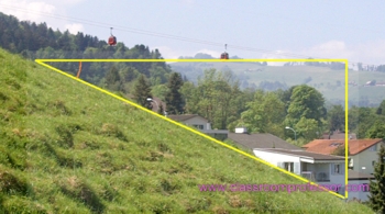
Here is the video. It includes a montage of varied shots of the cable car we rode on, and at the end there is an overlay of the angle of the slope itself (my apologies that the overlay doesn’t fit the slope very well – it’s an artifact of the video editor I use, due to changing from 16:9 to 4:3 aspect ratio, if you are familiar with video editing you’ll understand).

If you are interested, here is an interactive Google Earth view of the location where I shot the video:

So, back to the math. In geometry or space lessons, we teach about slope and angle, which can often be rather a dry topic without a real-life application. The slope of a ramp, a steep road, the cable for a cable car, are all such applications. Using a few simple props, your students can measure slopes and apply mathematics to analyse them and measure their stats. This can then be linked to:

  • slope expressed as a ratio (eg, 1:8 – I remember these from when I was a child)
  • slope as a percentage (eg, 12% – the more modern style)
  • the angle of the slope
  • the tangent of the angle, or the sine or cosine

Cross-curricular links could then be made to topics such as:

  • mechanical advantage in a certain slope (how much easier is it to move up one slope compared to one with a different angle?)
  • technology and engineering of building ramps, tunnels, cable systems, and so on
  • environmental aspects of sloped land, such as erosion
  • ‘optimal slope’ for certain purposes, such as driving a vehicle, mowing a sloped paddock, walking, etc.
  • aesthetic aspects of hilly or mountainous country, when compared to flat land (How does the scenery make you feel? Why do people like to take vacations in the mountains?)

What do you teach about mountains in your curriculum? Could you incorporate slope in applied lessons with your students? Please leave a comment below – I’d love to hear your thoughts.

Till next week…